What are Mid-Latitude Cyclones?
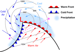
Also referred to as an Extratropical Cyclone, these are large areas of low pressure that form in the mid-latitudes (30-60 degrees N or S of the equator) and rotate counterclockwise in the northern hemisphere. They’re primarily known for their large “comma” shape that shows up on satellite imagery and for their ability to bring unpleasant weather to an area near you.
Though more severe in the winter months, these storms happen everywhere (in the mid latitudes, that is). Once fully developed, they typically consist of a warm front and a cold front, upon which upon maturing, producing an occluded front, where even more unpleasant weather is associated because of colder air taking over warmer air. It is the interactions between the air masses that cause the weather associated with the different fronts.
Though more severe in the winter months, these storms happen everywhere (in the mid latitudes, that is). Once fully developed, they typically consist of a warm front and a cold front, upon which upon maturing, producing an occluded front, where even more unpleasant weather is associated because of colder air taking over warmer air. It is the interactions between the air masses that cause the weather associated with the different fronts.
Why is the Effect of Climate Change on Mid-Latitude Cyclones Important?
Most of the world’s population lives in the mid-latitudes. These storms seem to affect people on a regular basis with our current climate. What will happen if the climate warms? Will these storms intensify? Who will be more at risk? Scientists are asking these same questions in hopes to find answers.
We know these storms can cause destruction through heavy snowfall, ice storms, and even severe thunderstorms. We also know what it means for our classes to get cancelled due to heavy snow and ice, or having to clean up a fallen tree after really strong winds and ice knock it over. It is likely that with climate change, these conditions would worsen. This could spell trouble for our economy as well, as shutting down an entire city because of an ice storm affects more than just that particular community, but rather all surrounding areas and maybe even that state.
We know these storms can cause destruction through heavy snowfall, ice storms, and even severe thunderstorms. We also know what it means for our classes to get cancelled due to heavy snow and ice, or having to clean up a fallen tree after really strong winds and ice knock it over. It is likely that with climate change, these conditions would worsen. This could spell trouble for our economy as well, as shutting down an entire city because of an ice storm affects more than just that particular community, but rather all surrounding areas and maybe even that state.
How can we look at future Mid-Latitude Cyclones?
We can use climate models to simulate current and future conditions. Scientists have used this process to look at everything from the ocean to agriculture. Just like scientists have been looking into climate change affecting pretty much everything, they have also been looking at changes in mid-latitude cyclones. We will examine two studies in particular to see just how different scientists project these changes to be.
The Impacts of Climate Change on Autumn North Atlantic Midlatitude Cyclones
J. Jiang and colleagues decided to base their study off of the Canadian Mesoscale Compressible Community Model (MC2) and Coupled Global Climate Model (CGCM2) by comparing the two results. By using the CGCM2 model, they were able to look at the different concentrations of atmospheric CO2 as a basis for their MC2 model. They ran the MC2 model at doubled CO2 levels and narrowed their study down to the northwest area of the Atlantic (mainly, eastern North America). They chose to look specifically at the frequencies and trajectories of future storms, the life cycle propagation, and changes in wind speed and sea level pressure from the period of 1975-1994 and comparing it to 2040-2059.
Jiang determined that the number of these future mid-latitude cyclones is likely to remain similar to those seen today. There is one major difference though: more storms are potentially likely to move towards the North Pole and Arctic region. This is evident in both the frequency and trajectory data, as the trajectories of the storms are proposed to become parallel to the coastline of eastern North America, with more of the storms moving in this direction.
As for wind speed, they noticed an increase in frequency of storms with wind speeds above 25m/s. In current storms, the strongest winds are located in the right forward quadrant of the storm, and in the future, the strongest winds will likely be located in the front of the storm on both the left and right side; this suggests that there will be more areas in the storm associated with higher winds. It is also important to note that the study suggests that there will likely not have a change in maximum wind speeds in the future, but rather just more storms with stronger winds will be prevalent. Similarly, they concluded that future storms would likely propagate about 13.5% faster, meaning they are likely to develop faster and move faster. As an overall trend, they did find that the minimum recorded sea level pressure would be lower than that of current storms.
 A figure from the paper showing the distribution of the cyclone tracks along the east coast of North America.
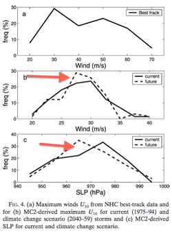 Another figure from the paper comparing current and future wind speeds in cyclones (middle chart) and current and future minimum recorded sea level pressure (bottom chart). The arrows point to the lines representing the future projections.
Will Extratropical Storms Intensify in a Warmer Climate?
L. Bengtsson and colleagues performed a similar task using models to look at potential storm changes. However, they based their data from using the ECHAM5 model and looked at future storms affected by the IPCC A1B scenario. This obviously produced very different results from the first study. Likewise, Bengtsson used different time frames for the basis of his study (1959-1990 compared to 2069-2100); nonetheless compared mid-latitude cyclones across the world and at different seasons of the year. For the sake of similarity, we will primarily look at winter storms in the northern hemisphere, near the east coast of the United States. Similarly, the study looked at wind, sea level pressure, and trajectories, but also looked in-depth at vorticity (the spin of a particle around its axis, where it helps determine whether a storm will remain strong enough to continue its trajectory or ‘spin out’ and die), precipitation, and the storm life cycle.
Bengtsson was able to determine very similar, but yet different results. Unlike Jiang, the results were focused more on winter cyclones in the northern hemisphere, but also briefly look at results from the southern hemisphere. While looking at just the northern hemisphere storms on the eastern North American coastal area, there appears to be a pole-ward shift, similar to the results obtained by Jiang. This meaning that more storms will have trajectories up the east coast of North America into the Arctic. Also, just like Jiang’s study, there will be a lower mean sea level pressure for future storms.
When Bengtsson looked at the frequencies of the future cyclones, there was an apparent decrease in frequency by 3-5%. They attribute this to the “reduced temperature variance in the lower atmosphere,” since temperature gradients are important when it comes to the formation of cyclones. Also, as an overall trend contrary to the idea that lower sea level pressure would imply stronger winds, this study found very little change in the wind speed. Though this would be an ‘average’ of the worldwide data, looking more closely at eastern North America in the winter, there is a very slight chance of possibly weaker winds in the future. The study looked at wind speed in-depth and found that a slight increase in wind speed was likely over the Atlantic Ocean but a decrease in wind speeds near Greenland. Likewise, for storms forming between 30-40 degrees north latitude, there was a decrease in wind speed with an increase in wind speed over the eastern United States and Canada. Hence, an average of very little change in wind speed overall.
A significant finding of this study dealt with precipitation. Generally speaking, for the whole world there is a variable increase depending on location. However, some areas are likely to see more and some likely will see less, there is a good chance of an increase in precipitation along storm tracks—meaning, more precipitation along the trajectories heading towards the Arctic. Not only this, but the models project and increase in extreme precipitation systems, so not only will there be more precipitation but it is likely to become more severe precipitation (i.e. heavier rates of precipitation and/or more accumulation).
 A figure from this study that shows mean sea level pressure, vorticity, wind and precipitation during the life cycle of a mid-latitude cyclone. Solid lines represent future storms. Time 0 represents the point at which the storm reaches maturity.
What does this all mean?
Of course, all these results are fine, but why should we care about them? We know that the Arctic ice is melting, which is opening up more areas for people to live. With this being said, if these results were to be accurate, more storms will occur in these areas, which will put more people at risk. Not only this, but even though these storms tend to form over land, many will travel up the coastline of the US into Canada (similar to some hurricane trajectories). With a significant portion of the world’s population on or near coastlines, any storms near the coast increase the potential for flooding. Since some models are suggesting more of the storms to likely become stronger, this means potentially stronger winds, more precipitation, and generally speaking, just a genuinely more potential for affecting our cities and our people. Of course, we cannot base our entire predictions off two different studies, so we need to take these results with a grain of salt. It will never hurt to look into building stronger buildings that can withstand stronger winds, building higher seawalls for coastal areas prone to flooding, and developing city-wide plans for evacuation of high precipitation storms or informing its residences how to safely ride out a storm.
While there are plenty of other studies out there to look at in regards to climate change affecting mid-latitude cyclones, most studies would agree that climate change will effect mid-latitude cyclones in some way. Though we may not know for sure, it is better to have some idea as opposed to no idea when it comes to our future.
While there are plenty of other studies out there to look at in regards to climate change affecting mid-latitude cyclones, most studies would agree that climate change will effect mid-latitude cyclones in some way. Though we may not know for sure, it is better to have some idea as opposed to no idea when it comes to our future.
References
Bengtsson, L., Hodges, K. I., and Keenlyside, N. "Will Extratropical Storms Intensify in a Warmer Climate?" Journal of Climate 22 (2009) 2276-2300. Print.
Jiang, J. and Perrie, W. "The Impacts of Climate Change on Autumn North Atlantic Midlatitude Cyclones." Journal of Climate 20 (2007) 1174-1186. Print.
With images used from:
http://www.aos.wisc.edu/~aalopez/aos101/wk13.html
http://www.eoearth.org/view/article/154602/
Jiang, J. and Perrie, W. "The Impacts of Climate Change on Autumn North Atlantic Midlatitude Cyclones." Journal of Climate 20 (2007) 1174-1186. Print.
With images used from:
http://www.aos.wisc.edu/~aalopez/aos101/wk13.html
http://www.eoearth.org/view/article/154602/
